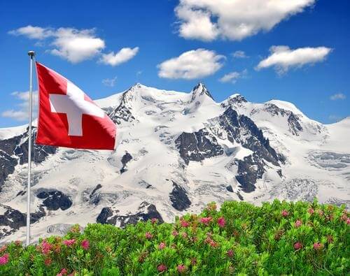
Monte Rosa (“Dufourspitze”) on the border between Switzerland and Italy,elevation 4,634 m (15,203 feet)
Now for our final journey through the Via Alpina, we’ll traverse the Blue Trail, the fifth of the international trails.
It passes through Italy, Switzerland and France, and consists of 61 costal and inland stages ranging between 7.3km and 25.3km in length. Walkers and hikers will discover quaint villages with intriguing culture, historical ruins and icons, national parks and some of the Alps most massive peaks as they trek from Riale, Italy to Sospel France.
Much of the Blue Trail incorporates the Grande Traversata delle Alpi (the Great Alpine Crossing or GTA). The GTA consists of varied landscapes, from alpine pastures and waterfalls to sea-level deserts. The Piedmont region boasts Monte Rosa, the Alps second highest mountain and the highest peak in Switzerland. The western and northern sides of the mount are covered with awe-inspiring everlasting glaciers. The Walser people colonized the southern slopes of Monte Rosa as far back as the 12th century. Today this culture still speaks its own, unique dialect of German.
Several national parks are highlighted along the Blue Trail including Gran Paradiso. This was the first national park to be established in Italy for the purpose of protecting the endangered Alpine ibex. Today there are several thousand of the wild goats within the sanctuary’s boundaries.
The Via Alpina Organization calls Monte Rosa, Gran Paradiso and also Monte Viso the mythical summits, perhaps because of their powerful statures which provoke observers to no longer acknowledge the passage of time.
Via Alpina’s Facebook page offers a photo gallery of some portions of the Blue Trail that would encourage any walker to embark on the trek as soon as possible. The iconic statue Madonna del Rocciamelone, the clear waters of lakes in the Germanasca valley, fortress ruins in Mercantour National Park, the Po Valley in colourful bloom – these are just some of the views that spark the imagination.
The Via Alpina organization has also granted travel fellowships to groups hiking the Blue Trail in the coming months. Éléonore Petit, Joël Percheron and his son William will trek portions of the trail with their canine companions to work out the most dog-friendly terrains of the trail. Also a group of at least 12 hikers will be mapping portions of both the Blue and Red Trail using OpenStreetMap. You will be able to read each group’s reports on the Via Alpina’s website.
Whether you decide to walk a small section of the Blue Trail, or all five international trails, the Via Alpina website is a grand resource with stage-to-stage descriptions, hiker’s comments and recommended highlights of culture, natural diversity and history. Make your own history by planning your next hiking journey around the splendour of the Alps’ mountain ranges.

